Overhead Traveller Information System (OTIS)
New electronic billboards around Hobart will share timely travel information with the community.
We are installing electronic signs on key travel routes around Hobart for our Overhead Traveller Information System (OTIS).
Also known as Variable Message Signs, these signs will show real-time travel times to key destinations. They can also show information about crashes, changes in weather, or unplanned incidents, so people on the road can make informed decisions about their travel.
We are also installing new Closed-Circuit Television (CCTV) cameras that will help our Traffic Management Centre monitor traffic and road conditions so they can feed timely messages to the signs.
We are installing:
We began this work in March 2024.
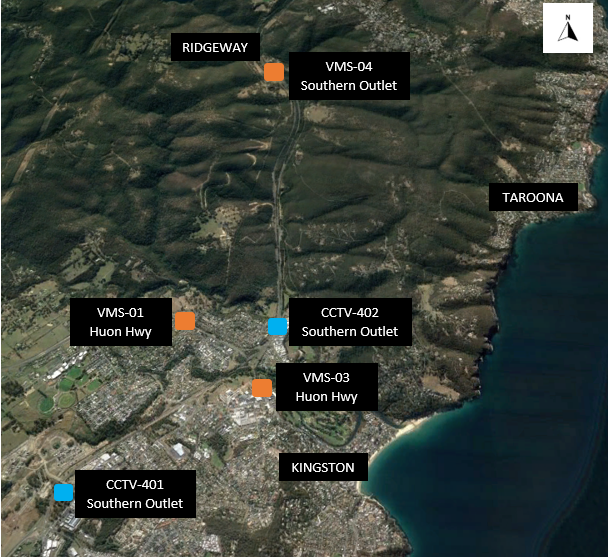
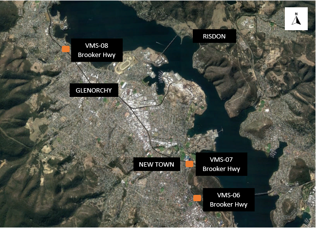
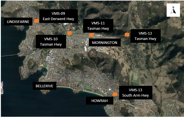
These are being installed in City of Hobart, City of Clarence, Glenorchy City Council and Kingborough Council municipalities. See the locations below.
All of our overhead signs have now been switched on and are displaying live travel times.
You might see the messages, colours, and formats of the signs change as we continue testing. Some signs may occasionally switch on or off – this is part of the process.
Our final stage of testing will make sure the signs are connected properly to our Traffic Management Centre so they can display real-time travel info, alerts about crashes, and safety reminders.
We will update the community once testing is complete.
This is expected to be by the end of April 2025.
The project is jointly funded by the Australian and Tasmanian Governments through the $22 million Intelligent Transport Solution. The overhead signs cost approximately $12.7 million in total.
| ||||||||||||||||||||||||||||||||||||||||||||||||||||||
Below are maps showing the project locations.


No.
The overheard message boards will give road users information about travel times, potential delays like crashes or severe weather, and the CCTV cameras will help monitor traffic and road conditions back at the Traffic Management Centre - they are not speed cameras.
Like other CCTV traffic monitoring camera across our road network, they will be live feed only with no recording and cannot be used for traffic enforcement or point to point speed monitoring.
Installing the signs and CCTV will allow the State Roads Traffic Management Centre to provide road users with information to make real-time decisions about travel routes, and in response to changing traffic conditions as a result of weather, crashes or unplanned incidents.
When not required for incident reporting, the signs will display road safety messages and current travel times to key destinations.
Information captured by CCTV will be used by the Traffic Management Centre for monitoring traffic and road conditions. This will provide greater visibility of prevailing traffic conditions and improve the ability to respond more effectively to incidents and other events.
Construction is expected to be completed in December 2024. Further electrical work, testing and commissioning is still to be completed.
We will update the public once testing is completed and a date has been set for the signs to go live. This is expected to be early 2025.
Before installing the signs or CCTV, vegetation at some locations needs to be assessed.
Where possible and practical, vegetation will be retained and trimmed. Vegetation requiring removal will be marked.
If you would like to find out more information and you have accessibility requirements, please contact the project team (details below).
You can find out more about Transport Services' commitment to accessibility on our website here: https://www.transport.tas.gov.au/accessibility
If you have any questions about these works, please contact stakeholder engagement specialist Lesley Turner, on 0447 965 624 or email OTIS@shawcontracting.com.au